
Port Masterplan
Layout
Optimizing the Maritime Frontier
The Tanjung Carat Seaport masterplan is a blueprint for integrated efficiency. By strategically organizing terminal operations and logistical infrastructure, the layout ensures high-throughput capacity while maintaining strict environmental and safety standards. This spatial organization supports the port's role as the primary deep-sea gateway for the South Sumatera region.
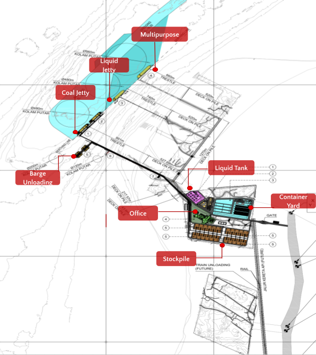
General Layout (230 hectare)
59.95 hectare
88.29 hectare
81.06 hectare
Liquid Bulk
Multi purpose
Jetty Area
59.95 ha
Primary waterfront infrastructure featuring high-capacity berthing facilities for bulk and container carriers.
Land Facility
88.29 ha
Core operational zone including terminal management, processing units, and integrated storage silos.
Backup Area
81.06 ha
Dedicated zone for logistics support, expansion potential, and multi-modal transport integration.
16–18 m LWS
14.8M m³
Terminal Infrastructure Phases
| Terminal Type | Planning Horizon | |
|---|---|---|
|
Dry Bulk Terminal
Coal, Ores & Grains
|
Short Term 2025–2028 | |
|
Panjang
870 m
Jumlah Bongkar Muat / Tahun
Up to 55 juta ton
Berth Occupancy Ratio
48–68%
Handling Rate / Alat BM
1000 ton/jam
Alat BM / Kapal
3 unit
|
||
|
Liquid Bulk Terminal
CPO & Derivatives
|
Short Term 2025–2028 | |
|
Panjang Dermaga
290 m
Jumlah Bongkar Muat / Tahun
CPO: up to 1.6 juta ton
PKO: up to 390 ribu ton
Berth Occupancy Ratio
CPO: 24–30%
PKO: 6–8.5%
Handling Rate / Alat BM
500 ton/jam
|
||
|
Multipurpose Terminal
Containers & General Cargo
|
Long Term 2033–2044 | |
|
Panjang Dermaga
340 m
Jumlah Bongkar Muat / Tahun
Up to 360k TEUs
Berth Occupancy Ratio
40–58%
Handling Rate / Alat BM
30 TEUs/jam
Jumlah Alat BM
2 unit
|
||